Thursday, February 3, 2011

White Tank Mountains

As often as I can, and with a clear conscience that my business trips do not appear to resemble boondoggles of any sort, I try to work in a hike or two after the end of a business travel day. In my luggage is packed a collapsible hiking stick, hiking boots, socks, appropriate day hike gear (a single bottle lumbar pack, flashlight, trail bar, compass, etc.) wicking shirt, jacket and a hat. Generally, I will check online a day or two before I leave for trails near where I am staying or working. But on this trip to Arizona, a co-worker recommended a visit to White Tank Mountain Regional Park in Maricopa County. Thank you, Stephanie for pointing the way to this interesting place.

The Regional Park is comprised of 30,000 acres of sharp rocky ridges, alluvial fans, saguaro cactus, flood-carved canyons and hundreds of petroglyphs. The north-south aligned White Tank mountains rise to 4,000 feet with most of the park facilities on the northeast section of the range. A small but diverse handful of shared use trails have been established, affording hikers of all levels to enjoy the area. Semi-developed (no electrical or water hookups) campgrounds are available for groups and individuals. Backpacking is permitted to a number of backcountry camping spots.

The park’s entrance is equipped with a modern and welcoming nature center staffed with fulltime and volunteer rangers who can direct you to trailheads and point out many of the park’s features which include flush toilets, guided tours and talks, playgrounds, ramadas complete with picnic tables and barbeques. The nature center also offers gifts, water and snacks for visitors. It shares a roof with classrooms and a public library. The building is adorned with public art, educational outdoor displays, a labyrinth and vista viewing benches. The park has something for anyone who enjoys being outdoors.

Since time was short and shadows were becoming longer, I elected to primarily hike Waterfall Canyon with a few side jaunts added to check other trailheads and vistas. It’s a short 2 mile walk into a canyon worn from centuries of flashfloods to one of the many “tanks” found in the area. These shallow granitic depressions are carved out at the base of steep water draws, creating natural pools or tanks that are no doubt frequented by wildlife all year.

In addition to viewing one of these ponds, the trail is lined with hundreds of ancient petroglyphs. Pamphlets and ranger talks help to enlighten visitors of their meaning and historical significance. Fortunately, these marks of ancient peoples have been treated with respect as little vandalism is apparent anywhere.

The park is certainly worth a visit if you’re in the Phoenix area. Though there is only about 25 total miles of trails throughout, the elevated views of the valley floor make for an impressive sight and a nice payoff for your hiking efforts. The saguaro, cholla and other cactus are very impressive with their abundance and softening texture to an otherwise barren landscape. The facilities are clean and well appointed throughout. Maricopa country should be proud of the good work they’ve done to make the park a destination for visitors and residents alike.
Thursday, December 30, 2010

Favorite Hikes and Outdoor Destinations: 2010

This last year provided many opportunities for walking on dirt under open skies. In addition to the list below, there were a few neighborhood open space park hikes that were quite nice, but certainly this list is of the best hikes taken in 2010. The list is alphabetical as it would be difficult to rank them by preference as each had something special to offer.

· Blue Ridge Parkway; Graveyard Fields Trail, North Carolina

· Bryce Canyon National Park; Queen’s Garden Loop, Utah

· San Juan Capistrano- Caspers Wilderness Park; Oak Canyon Loop, California

· Chino Hills State Park; Skully Ridge to Lower Aliso Trail, California

· Columbia River Gorge; Gorge Trail Loop, Oregon

· Crater Lake, Oregon

· Daley Ranch; Circumvent Loop, Boulder Loop (and others), California

· Dry Tortugas National Park; Fort Jefferson Walkabout, Florida

· Humbolt Redwoods; Boy Scout Loop Trail, California

· Indio- Mecca Hills; Split Rock and Ladder Canyon Trails, California

· Joshua Tree National Park; Hidden Valley, Barker Dam and Lost Palms Oasis Trails, California

· Laguna Coast Wilderness; Laurel Canyon Loop, California

· Prescott- Granite Dells; Peavine Trail, Arizona

· San Diego- Mission Trails; Oak Creek/Grasslands Loop and Cowles Peak Trails, California

· San Luis Obispo; Johnson Ranch Loop, Cerro Cabrillo Peak and Bishop Peak Trails, California

· Sequoia National Park; Tokopah Falls and Weaver Lake Trails, California

· Zion National Park; Kolob Canyon-Middle Fork Taylor Creek Trail, Utah

· Zion National Park; Narrows and Observation Point Trails, Utah


Looking forward to 2011 and those trails yet to tread as well as much loved favorites.

Thursday, May 27, 2010

Multnomah-Wahkenah Falls Loop

Multnomah-Wahkenah Falls Loop
Columbia River Gorge, Oregon
6.3 miles - 1,600 elevation gain
Moderately Difficult

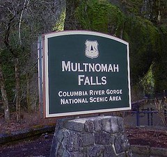
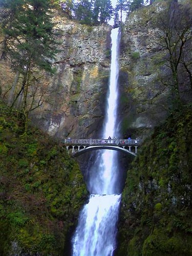
Multnomah Falls is arguably the second most recognizable feature of the Columbia River Gorge. The first is the river itself. This iconic spectacle is a popular tourist destination due to its beauty and comfortable tourist accommodations including a sit down restaurant, fully loaded gift shop, paved walkways and flush toilets. Highway access is quick and easy. There could be no better place for locals to bring visitors to Portland when wanting to truly impress them with the area’s natural beauty.

Most folks will take the ½ mile walk to the base of the first fall to peer upward from the circa 1914 concrete constructed Benson Footbridge. A number of others may even venture a bit more to peer dizzyingly over the upper fall’s cascade though it can produce some gasping breaths from those unaccustomed to steep walking. Even fewer take the opportunity to see some of the other wonderful falls higher up the gorge’s talus slopes and into the thick rainforest, which is exactly what I wanted to do during a recent trip to Portland to visit family and friends.

Depending on who you ask and which trail map you pick up, the Multnomah-Wahkenah Falls Loop hike is known either as Loop #1 or Loop #2. This map shows the route as Loop #2. Many of the hiking guides tell you to trek this in a clock-wise manner, from Multnomah Falls towards Weisendanger Falls but I would advise you to take this route in the opposite direction. Due to the crowds on the Multnomah Falls walkway (I’m hesitant to call this section a "trail," since it’s nicely paved, wide and well engineered. I spied many folks walking in flip-flops along the steep grade) I recommend saving this human traffic jam to the end of the hike. It would be a shame and misleading to allow this to set the tone for the remainder of the trek.

The hike is well documented on other sites including; Oregon.com Multnomah Falls Guide and Tripcart.com Multnomah Falls Guide
which give varying accounts of mileage and difficulty. In rechecking my calculations, the hike with side steps to lookouts and such is right at 6 miles with an elevation gain of approximately 1,600’.

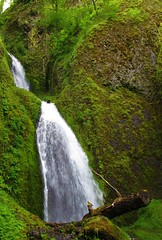
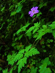
Begin and end the hike at the Multnomah Falls Lodge. From the falls proceed west, past the lodge and parking area as you parallel the Historic Columbia River Highway until you reach Wahkenah Falls. Begin your climb up the gorge’s south wall as you travel a good distance along Wahkenah Canyon creek. The canyon fills your ears with the music of the rushing creek, as moss draped pines and deep green ferns saturate your eyes. I honestly don’t think I’ve ever hiked in a more beautiful forest setting.

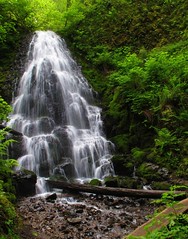
The climb up-canyon continues for about 2.7 miles until it levels off on the southern slope of the gorge. Along the way you’ll discover Fairy Falls, a lovely fan waterfall that invites many photos to be taken. Near the high point of the hike, you’ll have opportunities to visit Devils Rest, another 1.6 miles and Larch Mountain, an additional 5 miles from the trail junction.

When you begin to descend north along Multnomah Creek, several more small waterfalls are found including Wiesendanger and Ecola falls. Though the scenery remains spectacular, it is along this section of trail that you’re likely to encounter more hikers who’ve come up from Multnomah Falls, the number of which will increase to distraction and irritation until you reach the main lodge again.

I’m definitely repeating this hike on subsequent visits to the area but will also strive to summit Larch Mountain next time. From the photos and trail guides I’ve read, it should prove to be a rewarding experience. The top of the mountain is similar to a bald; unprotected by trees thereby offering unobstructed views for miles in all directions.

In addition to the other charms of the area, both in terms of the inhabitants and environs, this hike will be just one more reason to return. And soon.