 My first visit to Joshua Tree National Park was when it was still designated as a National Monument, nearly 45 years ago. Then and even now, I considered it a truly alien landscape as my eyes and imagination tried to take it all in; the massive boulders, expansive cliffs and the tentacled trees for which the park is named seemed to be from another place, far removed from the mere two-hour drive from home. But it is a very real place, deserving of its National Park status as unique and worthy of preserving for many more generations.
Hiking opportunities are numerous and include wide groves of Joshua trees, mysterious hidden canyons, desert washes, grottos and high ridges. Rock climbing is very popular here due to the impressive boulders and inselberg rock formations, most of which are comprised of quartz monzonite, a very rough, large crystalline form of granite. Camping is primative, that is to say, no flush toilets, electricity or waste hook ups. That does not discourage the many who visit and stay. It is not uncommon to find all sites filled to capacity during spring bloom weekends. But I come for the hiking now. My climbing days are 35 years and 35 pounds ago. Because the trails here are so rewarding, I rarely miss scaling the rocks here.
After reading a few reviews of what was described as “The Best Day Hike” in the park, it was decided that this trail would be perfect for the next trip to the park. The reviews of this loop hike are right on target, even if the mileage estimates vary from 6.2 – 7 miles, as this has become my new favorite hike in the high desert. When inquiring about this hike, it's best just to call it "North View-Maze-Window Rock" after the three trail segments that make up this particular loop.
 The hike has been known of for quite some time, but until recently it required some orienteering skills to complete. The entire hike with it’s various loops and trail junctions are now well marked and signed. Anyone with moderate hiking experience will be able to finish the hike according to the prescribed route. However at times, the trail becomes “subtle” as it crosses over barren rocks and through washes susceptible to the smoothing out of boot tracks and cairn scattering. If you pay attention, carry a trail guide with a simple map you’ll be fine. If you wander off trail to take advantage of a photo op or to water the plants, be mindful of where the trail is at behind you. In some sections, the trail is virtually invisible unless you were directly on it.
Finding the trailhead is a little tricky as it is not well marked. The 3-4 car maximum parking area (called by some the “borrow pit” lot because of a nearby old gravel pit) is located immediately north of roadway marker 24 near the park’s west entrance.
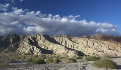
This loop hike takes advantage of three trails, North View trail, Maze loop and Window Rock loop. Each trail section provides it own character which makes this hike compelling and anything but boring. The North View trail offers spectacular views of the village of Joshua Tree, Twentynine Palms and Copper Mountain. The views are framed with stacked boulder fins and naturally formed cairns.
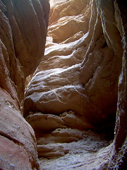
 The Maze loop leads you through low slot canyons, again built from stacked boulders, accented with cactus and juniper. The Window Rock loop presents a visual oddity in the form of a high rock window that at times will appear to be a large winged bird or just a square-like opening near a ridge line depending on your angle of view. Bighorn Sheep are readily spotted on this trail which also takes you through spreading groves of Joshua trees.
In short, it’s all here. Just about all of the visual, wildlife and floral attractions of the park can be found within this moderate difficultly loop hike. I can’t recommend it highly enough. This is the kind of hike that defines why I love to walk under open skies on paths unpaved.

A few guidebooks, “Afoot and Afield in the Inland Empire” by David and Jennifer Harris and “On Foot in Joshua Tree National Park” by Patty Furbush, describe the hike in more detail. Because the hike is still not high on everyone’s trail radar list, online resources are not abundant, but I did find these two nice references;
"Afoot and Afield" Book Excerpt
Trimble Outdoors Trail Guide


