Showing posts with label california. Show all posts

Sunday, August 14, 2011

Aliso and Wood Canyons: A hike in 3 acts

"Aliso and Wood Canyons Loop"
11 Mile loop hike
900' Elevation gain/loss
Moderately Strenuous

The OC Park system should be mighty proud because they are mighty clever. No doubt by design, many of the system’s wilderness areas are truly citadels of open and very wild spaces bumping up to the backyards of expansive and expensive housing developments. The Aliso and Wood Canyons Wilderness Park is no exception and may indeed be the prototype for such planning.

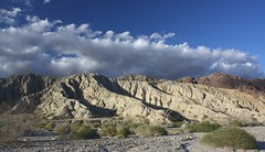
The park with its rambling name is almost 4,000 acres of former Spanish land grant ranchos hosting rolling hills, flat meadows and lush canyons and is positioned within long-walking distance from the Pacific Ocean as it overlooks the town city of Laguna Beach. What also distinguishes this park from many of its local cousins is its offer of a hike longer than just a few miles.  But like any in the park, the first and third acts of these hikes are at best, a dull production. However the long second act more than makes up for that blandness.

Begin your hike at the parking lot of the Visitor Center that is worth a quick peek.  Be sure to check out the fossils found in the sandstone and limestone formations that exist in the park. There’s a $3.00 parking fee, payable with a credit card. Portable toilets with hand washing facilities are adjacent to the lot. There may be running water for drinking somewhere, but I didn’t see any.

Just past the Center is the paved trailhead leading to the mouth of Aliso Canyon along Aliso Creek Trail.  The paved road is actually an access for the Also Water Management Agency and as such is a private road. Its open all weekend but reportedly there have been times when its closed during the week because of work being done on the parallel running creek. This portion, or first act, of the hike is unremarkable. Families with strollers or children on bicycles will find the wide, flat road useful and pleasant to enjoy but for the hiker or mountain biker, its just whatcha gotta do to get to the good stuff.

The good stuff lies just 1.5 miles beyond the parking lot trailhead at the clearly marked trailhead for Wood Canyon Trail.  I know of some hikers who will ride their bikes to this junction and lock them up on the handy bike rack located there.  Portable toilets are also located here, but again, no running water.

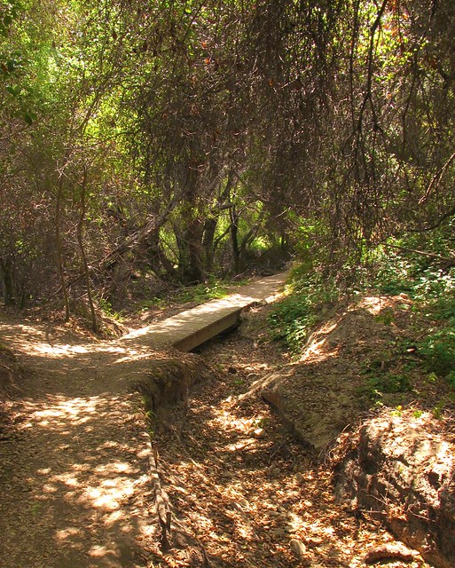
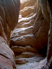
Follow Wood Canyon north for about .75 miles to the Dripping Cave junction which will be on your left and clearly marked like all of the trails at the park. It’s a short jaunt to the cave that you’ll find just beyond a wooden footbridge. 

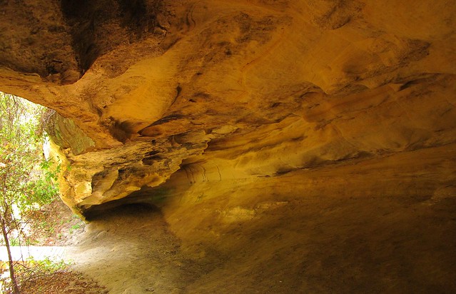
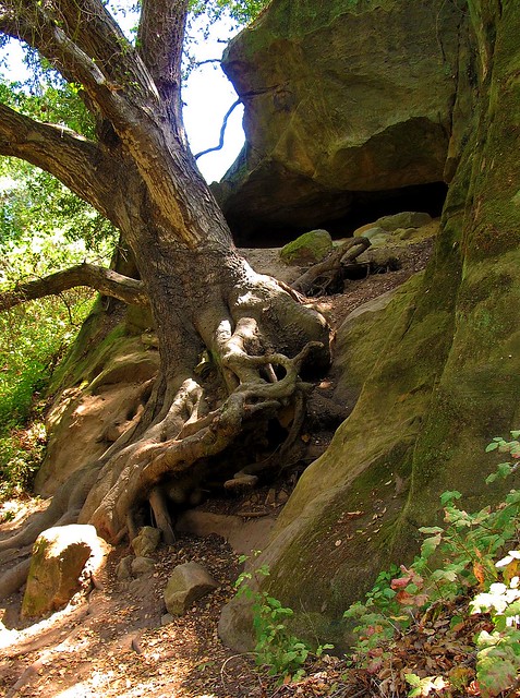
SIDE TRAIL: Before reaching Dripping Cave, you’ll see signs leading to Cave Rock, a substantial limestone formation eroded by wind and water to form several small caves. You’ll be able to see the rock if you stay on the main trail so there’s no real need to take the side trail unless you really want to.

After reading about how the cave was the supposed hideout of 19th century bandits, return towards the footbridge but instead of crossing it, veer to the left (north) trail that leads toward Mathis Canyon.  The trail becomes a bit steep for about 150 yards before it drops down again into a lovely meadow residing in the bottom of Mathis Canyon.  Before reaching the meadow, you’ll see even more caves as you walk beneath a cool oak canopy.  After crossing the eastern edge of this canyon meadow, you’ll intersect with Mathis Canyon Trail.  This is the last shade you’ll have for a while and the hike becomes much more challenging. 

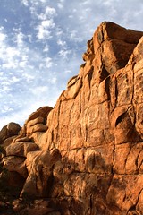
SIDE TRAIL: Before the climb, note the side trail to Oak Grove. Though overlooked by most, the grove resides in a narrow ravine that offers a bit of solitude from the rest of the folks on the trails. Deep and shady, I consider this a destination for a shorter, up-and-back 6-mile hike.  The adjacent rock formations also make it particularly worthwhile.

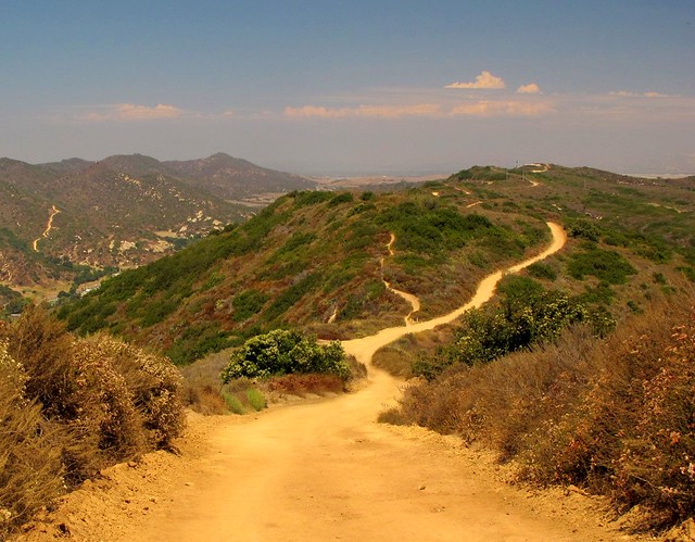
Mathis Canyon Trail provides a 550’ elevation gain in approximately 1.25 miles. It’s steep with few level, catch-your-breath sections until near the very end of the climb to the West Ridge Trail. At the junction of Mathis and West Ridge, turn right (north) on the wide fire road trail. Expect lots of other folks to also be there, many of whom started at the Alta Laguna Park in Laguna Beach.

The undulating ridge is a welcome walk after the climb to reach it. The views and breezes up there contain elements of the nearby ocean making it very pleasant.  Continue north on the ridge past the cell phone towers and water tank until you reach the Lynx trail on your right.  Take a moment to sit on the convenient rock at this junction to retie your shoes before making the descent back into Wood Canyon.  You’re about at the halfway mark of the 11 miles at this point. Parts of this downhill, single-track trail are steep and slick. Since you may also encounter bicyclists on this trail, be extra cautious.

At the bottom, you’ll intersect with Wood Canyon Trail and a right turn will bring you back to your starting point. If you brought a snack or a lunch, I’d find a shady spot here. There’s no more climbing to do, a sweet stream whispers nearby and there's lots of shade from the giant, spreading oaks found in the canyon. The entire scene makes for a nice place to regroup your thoughts, cool off from the exposed ridge and loosen up those boots if you like.

SIDE TRAIL: Hiking-only trails (Wood Creek Trail and Coyote Run Trail) parallel the main, shared use Wood Canyon trail. Signs show how to access them from Wood Canyon.  The upside of using these trails is that you won’t be dodging bikers but the downside is that you may find the creek a bit further away at times and perhaps a little less shade is offered, especially on Coyote Run.

Follow the Wood Canyon Trail southeast back towards Aliso Canyon and eventually the parking lot from where you started. The trail follows along Wood Creek that was still flowing with an impressive amount of water in August. You’ll cross the stream three times before once again reaching the Dripping Cave trail junction.  From there, your hike enters its third and final act as you rejoin the paved water management access road.  It’s during this last 1.5 miles that I’ll plug in my Nano and unwind as I listen to some nice music and soften my pace before reaching my car to drive home.


A tip of my Tilley hat once again to the OC Parks system.  Aliso and Wood Canyons Wilderness Park did what it was designed to do; provide me with an open sky and miles to hike beneath it without having to travel far to reach it all.


Helpful Links:


Monday, June 6, 2011

Whiting Ranch; Red Rock, Blackened Oak.


The best way to appreciate nearby trails and countryside is to view it all as a tourist would. You’re likely to discover surprising new things and places about your local environs that you might’ve missed otherwise.


There are places in Orange County that, if you squinted and shielded your eyes, closely resemble the sandstone cliffs in southern Utah or parts of Arizona. Such is the case with Whiting Ranch in Orange County, California.
 
 
Okay, so they’re not quite as impressive, grand or awe inspiring as Zion, Sedona or Moab but if you live in southern California, there are places of exquisite geological beauty practically in your back yard. If you know where to look.


The Orange County Wilderness Park area known as Limestone Canyon/Whiting Ranch is comprised of over 4,000 acres of rugged hillsides, narrow canyons and unique rock formations in the foothills east of the OC suburban sprawl. Narrow tentacles of the park lay between housing developments and immediately adjacent to shopping centers and freeways creating an almost surreal experience for the hiker or mountain biker. Within 10 minutes of turning your back to a busy McDonald’s and Target, you’ll find yourself walking under the canopy of centuries old oaks and shady sycamores with only a hint of the city heard on the wind.


One of the more popular hikes is to visit the Red Rock Canyon. Beginning on the Borrego Trail, this 5-mile up and back hike allows you to experience a few of the rare sandstone cliffs that can be found in the county. The trailhead begins literally adjacent to a large shopping center and winds its way through a canyon between two ridges filled with expansive home sites. For the first ¾ mile, you’ll catch glimpses of those homes, many of which were damaged by the 2007 wildfire that nearly decimated large sections of the park.
 Evidence of the fire is clearly seen with the presence of blackened oaks and thick layers of hardened ash still found in the soil throughout this portion of the park. The canyon and its oaks are recovering in remarkable fashion and as many naturalists will attest, such events are beneficial to the long term health of this wilderness.


The hike to Red Rock Canyon is moderately easy and about half of it is in the shade. As you leave the Portola Parkway parking lot ($3.00 fee) the trail immediately leads you into a riparian environment that is surprisingly lush for what is generally considered a very dry wilderness. You'll immediately be struck with the sight of blackened oaks, now festooned with new, green leaves and fresh branches as the trees attempt to reclaim their former stateliness. Before a mile has been traveled, an oak flat welcomes you to take in the increasing canopy and the view of a cave on the east wall of the Borrego Canyon trail. Though inviting, I'd recommend skipping it since it is well protected by a thick, moist green moat of poison oak.


The trail continues northeasterly as it leaves the shady oaks through often dry sandy washes bordered by chaparral and low scrub. At about 2 miles, the Borrego Trail junctions with the Cattle Pond and Mustard Road trails. Watch the trail markers carefully to find the Red Rock trail that parallels Mustard Road. This single track trail is located just beyond a picnic table equipped rest area and easy to miss. If you come to the Billy Goat trail junction, you've gone too far.


Follow the narrow Red Rock trail as it continues north towards a number of sandstone cliffs found at the end of another shadeless sandy wash. Anticipate being a little wowed when the cliffs are encountered for the first time. It will be difficult to imagine that you're in the same county as the Real Housewives, Disneyland and vast expanses of bedroom communities, condos and strip malls.

Please be respectful of these fragile formations and don't climb the cliff walls. Take some photos, enjoy a handful of trailmix and pick up the trash left by the guy who visited an hour before you. This kind of hiking destination demands a little extra effort to protect and maintain. Once you've taken in the unique vibe of the place, return the way you came to your car or make a left at the Mustard Road trail junction to explore more of the wilderness park.

When I hike this fun trail, I'm reminded how fortunate I am to have such an interesting place right down the road a bit, just past the Walmart and Arco station. If you live in the area, don't miss it and if you've got visitors from out of town anxious to visit the land of the Mouse, convince them that Mickey will wait and bring them here first.

The links below will lead you to a trail map and to the OC Parks website relating to this park.  Also note the link to flickr pages of the album of my photos of the park.


Whiting Ranch Photo Album; Flickr

Thursday, April 28, 2011

Community Wilderness Parks Rating: Caspers Wilderness Park

Not all community wilderness parks are created equal. All may afford city dwellers the opportunity to feel dirt beneath their heels and see a horizon filled with trees instead of cell towers but some do it better than others.  Having visited a few, I pondered a way to rate the parks on some sort of sliding scale. I wanted a system that could be applied to just about any community wilderness park so I just made this one up...like just now. The perfect community wilderness park (CWP) scores a 10 on all factors on a “CWP Rating System™.”  It's purely subjective, based on limited personal observation and subject to revision with each blog update.

The current CWP Rating System is comprised of six factors. Each factor is rated 1 to 10, 5 being average and 10 being highest. I tend to be a bit harsh in my ratings, so a “5” is not a bad score at all.

Ease of Access: The park is easy to find, can be reached without having to use granny low or a four-wheeled drive vehicle. Extra consideration is given for those accessible by bicycle.

Human Infrastructure and Facilities: Fresh running water, flush toilets, picnic benches, BBQ stoves, campgrounds, showers, trash and recycled waste receptacles, etc. Extra points for a visitor center and actual human staff or park rangers available.

Trails: Mixed use as well as single-track hiking-only trails of varying lengths and difficulty. Trails are well marked, maintained and actually lead to someplace interesting. Extra points for loops or connecting trails that allow for a 12+ mile hike.

“Remote-ness”: Can a visitor get far enough away from highway sounds and views of anything resembling community, i.e. housing developments, or other manmade structures that are not part of the park facilities? Extra points for parks in which this can happen relatively quickly.

Natural Beauty: Are the views, trees, geology, unique terrain, wildlife, meadows, ridge lines, canyons, streams, waterfalls, ponds and lakes, beaches or other natural features just beautiful? Extra points for natural aspects that are unique or special to the area.

Bonus Points: Easily obtainable trail maps, size of park, friendly volunteers, historical significance, special community events, portions of the park are wheelchair friendly, nicely paved roads, adequate parking and other things that make the visit pleasant.

It’s important to understand that this system is not really suited for large national parks or forests, backcountry destinations or other true “wilderness areas,” but those greenbelt areas that a community sets aside for residents and visitors to get a little outdoor time. Most of the parks have a certain family-friendly quotient, but all should afford even the solitary visitor the opportunity to escape for a few hours and to think of nothing more important than returning to a trailhead before total darkness sets in.

Let’s see how one of my favorite wilderness parks scores on the CWP Rating System. The first is Caspers Wilderness Park. I’ll feature it in a “favorite trail” review soon.

Located just east of San Juan Capistrano, California, Caspers Wilderness Park is part of the Orange County park system and is considered by many visitors to be the best of its kind in the OC.

Ease of Access: 9
The park is easily reached via California Hwy 74, aka the Ortega Highway. Bicyclists are often seen on Hwy 74 though many do not venture too many miles east of the park due to the highway’s infamous notoriety for frequent motorcycle accidents.

Human Infrastructure and Facilities: 7
The park is equipped with a nice visitor’s center, flush toilets, camping spots, a ranger-staffed front gate, good parking and paved intra-park roadways but troubled with frequent running water stoppages for multiple reasons.

Trails: 8
Many trails intersect and run the length of the park providing hiking, biking and riding adventures for trail users of all ages and skill levels. Some trails include sections near the Ortega Highway which makes for a reduced outdoor experience.

Remote-ness: 7
Because of its location, it’s a simple matter to get away from highway sounds and sights. However, some of the views along the upper ridges unfortunately include small enclaves of expensive homes and ranches.

Natural Beauty: 8
Caspers scores pretty high here. The tortuous and ancient oaks, spreading sycamores, relatively abundant wild critters and sometimes interesting geology (i.e. white sandstone bluffs and alluvial plain feeder valleys) gives the park visitor healthy dose of true wildness. The park is bordered by a number of ridges providing a variety of natural settings such as soft meadows, rocky steam beds, darkly shaded canyons and bare ridgelines.

Bonus Points: 6
“Adventure Day” and a number of other activities occur at the park offering families a nice outdoor experience. The park has good facilities for horses, including pipe corrals and watering troughs. Parking is more than adequate and the volunteers here are helpful and friendly.

Total Subjective and Irrelevant CWP Rating System Score: 45 out of a maximum of 60.

Caspers is one of my favorite, nearby default wilderness areas. I fell in love with the place immediately and find myself returning many times a year.

Next time, I’ll review the West Ridge to Oak Trail Loop, a sweet trail that always pleases when visiting Caspers.

For more information please visit the sites below:

Caspers Information: OC Parks

Caspers WP Trail Map
 
Caspers WP Photo Set

Tuesday, April 19, 2011

Best Day Hike in Daley Ranch: "The Whole Enchilada"

If the world was perfect and I could control the outcome of all things, I would have my own private Daley Ranch. It is for me a refuge where it is possible to replace the sound of highway traffic with bird song and the sound of my own breathing. It is a place where I can see an expanse of only wild things rather than Wal-Marts. Within its 3,000 plus acres I can walk and take in the soul healing power of a dirt path and open sky. It is a small sliver of wilderness within a short distance of a freeway offramp. It is heaven within reach.

Located at northeast end of Escondido, California, Daley Ranch is a secluded valley that is an unique amalgam of rolling ridges, boulder decorated hills, ponds, wetlands, wildlife, massive oaks and view-worthy peaks. At one time, the land was owned by the Daley family who would use the property as a summer retreat and quasi-dairy operation. Though the land changed hands a few times, the City of Escondido wisely purchased the property, added a few additional acres to include Stanley Peak and dedicated it as a wilderness recreation park in 1997. Immediately adjacent to the park is Dixon Lake a small fishing lake with picnic areas and paddle boats. Though Daley does not charge for parking or admission there is a fee for entering the Dixon Lake area.

For a day-hike area, it’s really hard to beat if you live in the North San Diego or South Orange County areas. The hiking varies from relatively easy to moderately difficult as the network of over 20 miles of trails traverses across ridge lines and meanders through rare Engelmann oaks. In addition to the nice selection of short hikes available, I think it’s the oaks and boulders that appeal to me most. For being so close to home and major metropolitan areas, it’s a beautiful place to visit now and again.

There are three recognized trailheads to the park, the primary one being near the Dixon Lake entrance off of La Honda. Free parking is available immediately in front of the Ranch’s main gate. Parking in the main lot is permitted until dusk. (NOTE: On weekends, a shuttle service offers rides to folks wanting to visit the main ranch house, barn and picnic area. Watch out for the bus and the mountain bikers sharing the main access road.) Two of the most popular hikes are the Boulder Loop; moderate 3.5 mi and what I call the Sage Loop; moderate 4.5. Each of those hikes will lead you back to the main gate.

My hike of choice (when I have the time) encompasses the entire ranch area, providing a chance to see just about all of the terrain and beauty the place has to offer. You’re also likely to find some solitude once you hike to the outer edges of the park as few people tend to go north of the ranch house. I call this hike, “The Whole Enchilada Loop.”

By following the below list of trail names in order, you’ll get in just under 14 miles of good hiking and a peak to boot. Download the trail map located at the link below as a reference to this hike.

THE WHOLE ENCHILADA LOOP
  • Creek Crossing (look for Dixon Lake to the south)
  • East Ridge
  • Sage (look for seasonal ponds in the area)
  • Stanley Peak (nice views to the east)
  • Sage (pass by Mallard Pond on your left)
  • Ranch House (chemical toilets and picnic tables)
  • Jack Creek Meadow (eastern loop portion)
  • Hidden Springs (the steepest one-mile section in the park)
  • Engelmann Oak (head north at the junction)
  • Cougar Ridge (nice views to the west)
  • Boulder Loop (favorite section of the hike)
  • Ranch House (head south to the parking area)

If you find that daylight is rapidly vanishing or your endurance is lagging a bit, the hike itinerary can be easily be shortened to shave off a few miles by taking any number of shortcuts. One of the surprisingly nice shortcuts is via “Bobcat Trail” which bisects the Engelmann Oak Loop. On a very warm day a few summers ago, I began to run out of water so took this trail to shave off a mile. The Bobcat trail is a shaded, one track trail that was a nice change of pace from the hot sun that day.

Water is only available at the La Honda parking area and during the summer, this rocky, inland valley can become quite warm so bring plenty. A pay phone and chemical toilets are available at the ranch house.

I'm not sure if I'd label the trails at Daley Ranch as "destination hikes," but you really shouldn't miss the place if you're within a hour's drive. Actually, heaven's worth even a two hour drive if you need a little slice.

Daley Ranch Trail Map

Daley Ranch Information

Daley Ranch Photo Set


Wednesday, March 16, 2011

Best Day Hike in Lower Sequoia NP: Marble Falls Trail

Sequoia National Park is more than just big, fat trees. For certain, those fatties are worth seeing, touching and loving anytime and often, but winter visits are sometimes made a bit more difficult with closed highways and neck deep snow covered trails. Fortunately, Sequoia offers diverse environments allowing treks year round.


Approaching the park from the south via Hwy 198 through Visalia and Three Rivers, the “Ash Mountain and Foothills” portion of Sequoia is often well below the snow line while still providing inspiring waterfalls, roaring rivers, oak and laurel shaded paths and encounters with wildlife regardless of the season.


One of the more popular trails there is the 8 mile round trip hike to Marble Falls.  The trail is a moderately difficult hike with a 2,000 foot elevation change.  To access the trailhead, enter the park from the southern gate, (Ash Mountain) driving north-easterly on the park’s Generals Highway to the Potwisha campground, elevation 2,100 feet.

Entering the campground, continue along its roadway to the upper, northern end (near campgrounds 14 and 16) where a narrow access road leads to a small parking area.  Since bears frequent the area, a metal “bear box” is available at the trailhead to safely store any coolers, food and toiletries carried in your car. 

Though you may not actually see a bear, it is highly likely you’ll see evidence of their presence in the form of scattered trash, fecal matter, scarred tree trunks and other signs.  Be smart and use the bear box.

The trail parallels a concrete aqueduct and the Marble Fork of the Kaweah river for .2 miles before it begins a quick, switched-back climb on the east side of the river gorge. New trail signs indicate that from this point, the falls are 3.9 miles up canyon, and I believe it.


Oaks, laurels and yucca dominate the chaparral plant life that is accented in the spring with wide swatches of wildflowers. The trail continues to climb as it follows the contours of the river gorge. This is my favorite type of hike since the trail alternates between climbing and leveling off. This allows you to rest while moving to the next uphill section of the hike.


As the trail climbs, the terrain and plants change to more alpine-like with occasional bare rock outcroppings that provide a particular drama to the often narrow, steep drop-off single-track trail. During the wetter months and the spring thaw, you will need to cross any number of hillside creeks that exist in draws. The trail is also alternatively shady and sun drenched as it moves in and out of these foliage and even moss-dense sections of trail.


At about 2.5 miles you will be afforded a distant, but good view of the falls, actually a series of cascades of varying heights, at the bottom of the narrow gorge. You will definitely hear the river and the falls before you see them and the roar only grows more powerful as you near the end of the trail.

When you reach the place where the trail meets the river, you’ll be treated to up close views of the largest cascades as they wash over broad slabs of white marbleized quartz. Looking up at the west side of the gorge, you’ll witness a massive deposit of this quartz, the outcropping as tall as the mountain containing it, looming over the river. Though you might be tempted, it is not recommended to venture any further up river. The rocks are slick, the river powerful and any missteps, unforgiving.

After absorbing a bit of the energy echoing from every surface, return the way you came. During the spring and summer months, be sure to check yourself for ticks that like to hang out on shrubs and low laying flora. Keep an eye for passive, fearless mule deer and furtive rattlesnakes along the way.  Both are numerous at times. 

There are many online trail guides for Marble Falls if you need additional information. The park rangers at the Foothills Visitor Center can also provide you with the latest trail conditions.  Though it's an easy hike to find and follow, here's a map that may be useful: Sequoia NP Foothills Area. Other helpful maps can be found on this site as well.

It is important to mention that during the summer months, the foothills area of Sequoia can get quite warm so bring plenty of water, and wear a hat!

Monday, February 21, 2011

Rock and Awe; Best day hike in Joshua Tree NP

My first visit to Joshua Tree National Park was when it was still designated as a National Monument, nearly 45 years ago. Then and even now, I considered it a truly alien landscape as my eyes and imagination tried to take it all in; the massive boulders, expansive cliffs and the tentacled trees for which the park is named seemed to be from another place, far removed from the mere two-hour drive from home. But it is a very real place, deserving of its National Park status as unique and worthy of preserving for many more generations.

Hiking opportunities are numerous and include wide groves of Joshua trees, mysterious hidden canyons, desert washes, grottos and high ridges. Rock climbing is very popular here due to the impressive boulders and inselberg rock formations, most of which are comprised of quartz monzonite, a very rough, large crystalline form of granite.  Camping is primative, that is to say, no flush toilets, electricity or waste hook ups.  That does not discourage the many who visit and stay. It is not uncommon to find all sites filled to capacity during spring bloom weekends.  But I come for the hiking now. My climbing days are 35 years and 35 pounds ago. Because the trails here are so rewarding, I rarely miss scaling the rocks here.

After reading a few reviews of what was described as “The Best Day Hike” in the park, it was decided that this trail would be perfect for the next trip to the park. The reviews of this loop hike are right on target, even if the mileage estimates vary from 6.2 – 7 miles, as this has become my new favorite hike in the high desert.  When inquiring about this hike, it's best just to call it "North View-Maze-Window Rock" after the three trail segments that make up this particular loop.

The hike has been known of for quite some time, but until recently it required some orienteering skills to complete. The entire hike with it’s various loops and trail junctions are now well marked and signed. Anyone with moderate hiking experience will be able to finish the hike according to the prescribed route. However at times, the trail becomes “subtle” as it crosses over barren rocks and through washes susceptible to the smoothing out of boot tracks and cairn scattering. If you pay attention, carry a trail guide with a simple map you’ll be fine. If you wander off trail to take advantage of a photo op or to water the plants, be mindful of where the trail is at behind you. In some sections, the trail is virtually invisible unless you were directly on it.

Finding the trailhead is a little tricky as it is not well marked. The 3-4 car maximum parking area (called by some the “borrow pit” lot because of a nearby old gravel pit) is located immediately north of roadway marker 24 near the park’s west entrance.

This loop hike takes advantage of three trails, North View trail, Maze loop and Window Rock loop. Each trail section provides it own character which makes this hike compelling and anything but boring. The North View trail offers spectacular views of the village of Joshua Tree, Twentynine Palms and Copper Mountain. The views are framed with stacked boulder fins and naturally formed cairns.

The Maze loop leads you through low slot canyons, again built from stacked boulders, accented with cactus and juniper. The Window Rock loop presents a visual oddity in the form of a high rock window that at times will appear to be a large winged bird or just a square-like opening near a ridge line depending on your angle of view. Bighorn Sheep are readily spotted on this trail which also takes you through spreading groves of Joshua trees.

In short, it’s all here. Just about all of the visual, wildlife and floral attractions of the park can be found within this moderate difficultly loop hike. I can’t recommend it highly enough. This is the kind of hike that defines why I love to walk under open skies on paths unpaved.


A few guidebooks, “Afoot and Afield in the Inland Empire” by David and Jennifer Harris and “On Foot in Joshua Tree National Park” by Patty Furbush, describe the hike in more detail. Because the hike is still not high on everyone’s trail radar list, online resources are not abundant, but I did find these two nice references;

"Afoot and Afield" Book Excerpt

Trimble Outdoors Trail Guide

Tuesday, April 27, 2010

Johnson Ranch: San Luis Obispo

Johnson Ranch is the newest addition to San Luis Obispo's open space park inventory. It's not a large park, the main trail only offering about 4 miles of easy going, single track hiking, but it is a beautiful park, maybe even strikingly so at certain times of the year.

I was fortunate enough to happen upon it on a recent business trip to the San Luis Obispo area. Heading towards a more familiar trail at the end of the day, I spied the parking lot and trailhead from the highway as I was nearing my hotel. After a quick U-turn, I found a handful of friendly local hikers and moutain bikers who were making the best of the fading light and expansive green hillsides decorated with a narrow brown ribbon of trail threaded along the undulating glades.

The new park has gained more than a few online fans who speak of the history of the ranch and its environs. In the spring, the park's hills can be verdant, lush. During the summer months, the dry grasses give the landscape a soft, satisfying and warm glow, accented with deep green oaks offering welcome shade.

The trail is supplemented with a number of wooden bridges that help you to navigate across ravines and a year round stream, the habitat of a small number of steelhead trout. As such, a good portion of the park, while open to view and enjoy from a distance, is so sensitive that hikers are not allowed.

Unfortunately, a growing number of feral pigs haven't been told of the sensitive nature of the area and have made themselves a bit of a nuisance. In addition to tearing up some countryside, they've been stirring up sediments in the stream making life for the rare steelheads a bit tougher. Some hikers have reported confronting the pigs, but no injuries have resulted from the encounters.

Johnson Ranch is certainly not a destination hike, but if you find yourself in the San Luis Obispo area for any reason, do take some time to check this place out. There is a remarkable, sprawling oak tree that spreads up, back into the ground and then out again that makes the trip worth it. The trail travels beneath this wonderful tree, so you can't miss it.

The link below will lead you SLO's Park and Recreation website. Other Open Space Parks are listed, including the Irish Hills Natural Reserve, which has some very sweet trails that I will describe later.

SLO Open Space Parks

Wednesday, February 24, 2010

Mecca Hills: Utah Lite

Ladder Canyon
There are hikes you take for no other reason than they're fun. Not necessarily challenging, no peak-bagging, but just plain fun. The slot commonly called "Ladder Canyon" in the Mecca Hills south east of Indio, CA is exactly one of those hikes. When walked as part of a loop through Painted Canyon, the hike is about 5 miles, moderate in difficulty and worth the trouble to find it.

If you live in Southern California or find yourself in or around Palm Springs in the cooler months, you MUST do this hike.

From the parking area (direction in the links at the end of this post) you walk among high sedimentary rock walls that echo the sound of your footsteps in the trail's soft sand. After about a quarter mile, the canyon makes a wide right turn. To your left you'll notice a jumble of boulders, the result of a long ago cave-in at the mouth of a narrow slot canyon. Rock cairns and stones creating a large arrow in the sand, pointing the way may also be present to help guide you.

The boulders that create the cave-in are easily scrambled and you'll find your first of several ladders positioned by like-minded hikers to lead you to the bottom of the slot canyon. If you can do this ladder, you can handle the rest that lead you to the views from the upper ridge lines atop the canyon. The trail is well marked and once again cairns and stone arrows help to keep you on track.

After following the ridge in a mostly northerly direction, you'll head down into Painted Canyon back towards the trailhead. Painted Canyon is also noteworthy for the many incredible geological displays at each turn. You'll have a couple more ladders to negotiate down before the hike is completed and I predict you'll be tempted to do the entire thing all over again as you pass the caved-in entrance to the slot canyon on the way back to your car.

The below linked description says that it's a difficult hike. If you're in relatively good health, it's not. If you are a bit leery of heights or climbing wobbly ladders, you may not want to try this but I can't recommend the hike highly enough. Palm Springs Guide: Mecca Hills

The Mecca Hills area is one of those California gems offering landscapes unlike any other I know of, with the possible exception of portions of southern Utah. Certainly smaller in scale, it can serve as a proud runner-up to the canyons and hoodoos of Utah. Think of the Mecca Hills as "Utah-Lite," and if you're fortunate enough to live in southern California, just a few miles off Interstate 10. I recently spent a weekend there with some hiking friends, concentrating our exploring to the Painted Canyon area. Though we saw much, we barely experienced an introduction to this must-return-to-soon destination.

For more information on the area, be sure to pick up "140 Great Hikes Near Palm Springs," which lists many other trails in and around the area. It's available from Amazon for about $15. 140 Great Hikes

Like most deserts, there is no water to be found nearby so be sure to pack in plenty. The only other tip I'd pass on is that you might want to wear some gloves to help protect your hands on the rough canyon walls and boulders. And if you use trekking poles, you may want to have a way to attach them to your pack when not in use. You'll need both hands to mount, dismount and use the ladders safely.

I've posted a photo album of the area on my flickr pages:  Mecca Hills Photo Album

Favorite Hikes in Joshua Tree NP

Joshua Tree National Park is a most unique place and a special one in my history with the outdoors. I originally visited the park as a young Boy Scout when it was still a national monument. The massive boulders and other world qualities of the landscape gave rise to many wild imaginings and simple adventures.

As a young adult, I returned to climb monstrous boulders as I learned and then taught the basics of rock climbing. I would return many times to climb the rocks there, hone my skills and test my nerves. It would be the last place I would climb as well. February 18, 1989 was the last real climb I went on. I remembered it began to snow on a 3 pitch climb and my climbing partner and I had to rappel off the face to safety.

As an adult, I have returned to walk about the canyons, washes and ridges. Each visit brings new discoveries and new found appreciation for this most unique place. If you haven't been, you must see this place with your own eyes. It's a bucket list destination.

My current favorite hikes in the park are, in general order of preference:

Lost Palms Oasis: A 7.4 mile up-and-back that begins at Cottonwood Springs. For the first 3.2 miles, it is a moderate hike but increases in difficulty for the last .5 as you approach a deep canyon bearing a surprising number of California Palms. You can add an additional 1.5 miles by taking the Mastodon Peak loop, which intersects with this trail.

This hike provides a wide variety of terrains, views and fauna. The only thing it does not give you are Joshua Trees. PROTRAILS: Lost Palm Oasis


Lost Horse Mine: You can do this hike as an up-and-back to make it a 4 mile hike or do it as a loop for 6.2 miles. It’s a moderately strenuous hike that gives you some great views of the park as you climb, as well as a great visit to an old gold and silver mine, complete with tipple and mill ruins. NPS Map


Pine City: A 3.5 mile up-and-back hike to the only pine trees in the park. A moderate hike that has options to make it much longer. The trail leads to a collection of giant boulders shaded by California Juniper and Pinon Pine trees. A wonderful place for lunch as you sit beneath the shade of the trees and boulders. The “city” was apparently a small collection of wooden cabins inhabited by miners who worked the nearby Lucky Boy Mine. LOCALHIKES: Pine City


Barker Dam / Petroglyphs Loop: An easy hike of maybe 1.5 miles. It is my favorite to take as the last hike of the day. The setting sun casting a warm glow on the rock faces. You are more likely to see a few critters visit during this time as well. The trail takes you to the small lake created by a dam built to hold water for cattle then into a boulder lined valley. There is a small side track to the “Movie Petroglyphs” named so because a movie crew enhanced ancient petroglyphs with some paint to make the filming of them easier. MODERNHIKER: Barker Dam Loop


Hidden Valley Nature Trail: This easy hike is only 1 mile but is a complete delight. This small valley is home to an abundance of life. Do not pass it up. PROTRAILS: Hidden Valley Loop